Last fall, I scheduled a trip to Big Canyon, a tributary of the Little Colorado River on the Navajo reservation. A bunch of people showed for this trip, and on the first day, we entered the wrong drainage to connect down into Big Canyon. We ended up wasting too much daylight farting around in that drainage, and aborted the trip before it even got started. It was a huge disappointment. Naturally, I wanted to fix this blot on my record, so I put the trip on the calendar again for this spring. There was some last minute scrambling to figure out who was coming and who wasn't, but a team of five canyoneers from Phoenix, Flagstaff and St. George Utah eventually coalesced and we headed up Friday night to camp on the rim.
After a long shuttle on dusty Navajo roads, we dropped down through a
break in the Coconino sandstone. This involved rock-hopping and
butt-sliding down a massive talus slope.
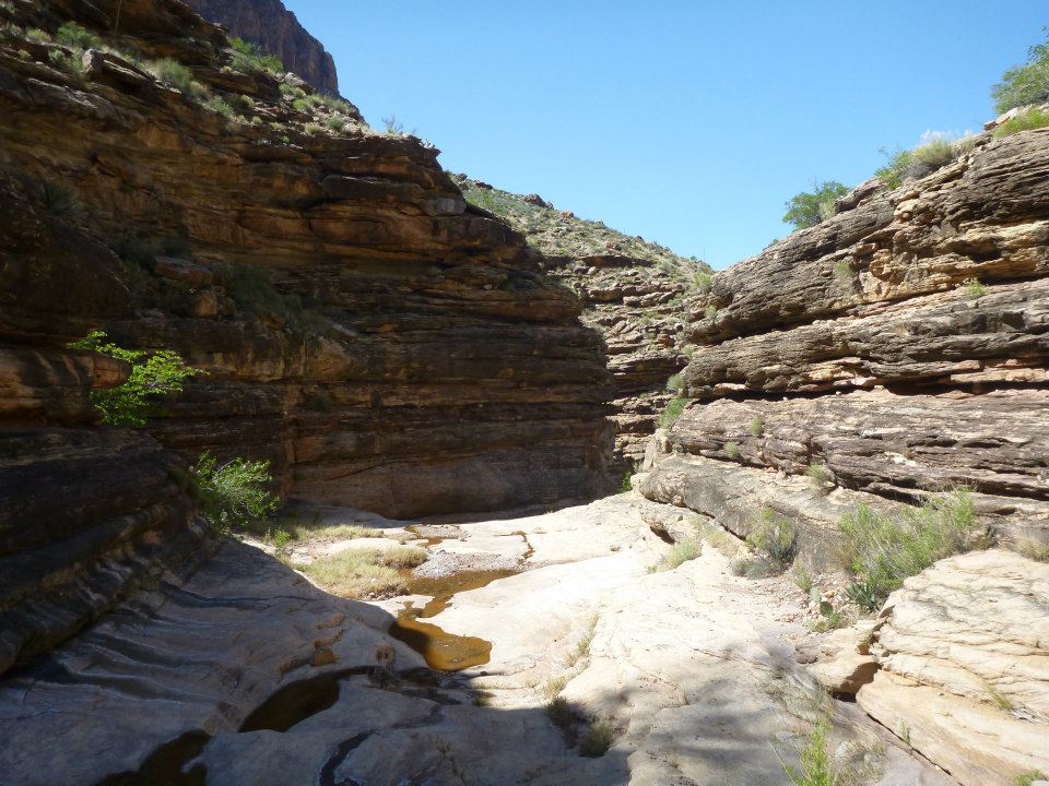
Once safely at the bottom, we followed obscure washes further into the
canyon. The going at this point was mostly easy, with firm sand, little
rock-hopping, and easy route-finding.
Eventually, the canyon starts to drop into the Redwall. Huge walls rear up from both sides of the canyon, and the scenery starts to get spectacular.
The first technical drop in the canyon is an 80 foot rappel that leads into a
stunning, spring-fed chamber. Waterfalls with heavy mineral content
make for turquoise blue-green water.
Just around the corner, the canyon makes a 100 foot drop down a shushing
waterfall. You rappel right down the middle of the waterslide.
Goes without saying, but this is incredibly fun. And given the price of
admission in terms of physical and technical difficulty, you're all but
guaranteed to have it all to yourself.
Below the second drop, the canyon opens up. While the canyon is no longer a narrow slot, the mineral content of the water makes for huge travertine
waterfalls. We followed a series of rappels right down the middle of
these formations.
At the bottom, the canyon drops into the Little Colorado River. Most of
the year, this river would also be flowing turquoise, but recent rains
had muddied the waters. All the same, its a spectacular area. We waded
and floated right down the river to our campsite.
The exit the next day follows the Salt trail back out the rim. This is
the trail that the Hopis use to travel to the confluence of the Little
Colorado and Colorado rivers, to visit the sipapu - the place where they
believe their ancestors emerged from the earth. Despite the trail
being older than the park itself, it was not easy, climbing 3000 feet
straight up. While easy to follow, it degenerates at times into a free
climb straight up the rocks.
Between this trip, and Shinumo Wash last fall, the bug has bitten me hard.
I've been backpacking for many years, and these kinds of trips are
everything I love about backpacking. Its seriously remote wilderness,
incredible beauty in both the big vistas and intimate slots, and tons of
fun and variety in the swimming, rappelling and rafting. All in one of the keystone national parks on the entire planet. Grand Canyoneering is the next
level of outdoor adventure, and I'm already planning my next trips.
Giddy up!
A few weeks back, I took a trip down to southern Arizona with my wife. The goal of this trip was to visit Sycamore Canyon in the Pajarita Wilderness. To cut the drive in half, we started by driving down to Tucson on Friday night, camping at Catalina State Park just outside of town.
Catalina was a wonderful refuge. I went to college in Tucson, but despite that I never visited the park, preferring the fee-free areas on the south side of the mountains. So it was nice to finally get a look around the park. Shortly after waking, we took a short hike on the Romero Ruins trail.
After breakfast in Tucson, we hit the road for Nogales and the border. Sycamore Canyon is a special place for me, as it was the second overnight, solo hike I ever took, way back in the late 90s when I first got into backpacking and the outdoors. I revisited the canyon several times during my college years, and I have a lot of affection for it. So I wanted to share the experience with my wife.
Sycamore Canyon is nearly a perfect date hike. Its easy, with no real elevation change, and incredibly pretty, with rock formations, slot narrows, waterfalls and green vegetation. The drive in from Nogales takes you over hills with great views off in all directions. The start of the hike passes by historical ruins from Arizona's frontier days. It's an all-around great place to hike.
On the way back from the border, we decided to stop off at Tumacacori National Historic Park. I knew, vaguely, that this was a historical building from Arizona's early days, but my knowledge didn't go deeper than that. It was a revelation to discover the place pre-dated the founding of the country. We explored the park, as well as swinging over to Tubac right before it closed, rounding out the trip in great fashion.
Here's another historical look back at a trip I did a few years ago. For this one, I didn't have enough footage to put together a video, so I'll have to try to do it justice via text.
After my first successful Grand Canyon hike in February of 2013, I wanted more. I came up to the park in March for a day trip. I intended only to do a day hike down to Ooh-Aah Point on the South Kaibab Trail, but I was feeling so good I ended up doing a massive South Kaibab - Tonto - Bright Angel day hike!
More importantly, though, I was there to snag a permit. Todd Martin's book said that by far the best way to get a Grand Canyon permit is in person, and my experience reflected that. When you submit a permit request by fax, you basically have to submit and hope to get lucky. When you go in person, however, you get immediate consideration, and the ranger will actually work with you. They'll tell you things like "Horn Creek is full, but Monument Creek is open." After a conversation with the ranger, I secured a permit for an overnight camp at Monument Creek.
Returning in April, I set off down the Bright Angel Trail. The corridor trails in the Grand Canyon, while scenic, are kind of a horror show if you spend much time on other trails. They're crowded, steep, hot, and dusty as hell from all the hooves and boots beating them into oblivion. The trails are littered with mule dung. The animals are all aggressive beggars. Its not a pleasant hiking experience, and it boggles my mind that, for the 1% of visitors to GC who stray beyond the pavement, for the vast majority of them, THIS is what they associate with the Grand Canyon backcountry. But still - if the traffic wasn't condensed onto the corridor trails, the rest of the trails would just be that more overburdened. So you live with it. Happily, I was able to chew up the miles quickly and make it to the relative oasis of Indian Gardens without much delay.
From Indian Gardens, the Tonto trail snakes out to the west. Now this was more like it. After the dusty, punishing Bright Angel trail, the Tonto felt like a refuge. It stays almost miraculously level as it snake in and out of side drainages along the Tonto Plateau.
Once you leave the corridor crowds behind, the trail becomes silent. That's what's amazing about the Grand Canyon, and incredibly hard to convey to those who haven't been there. It wallops you over the head with space and silence. You can get a taste of this from the rim, but to really feel it, you have to get down into the canyon. Its austere, but each little bit of beauty stands out even more for how harsh and spacious everything is.
After passing Horn Creek, the trail swings around Dana Butte and views of the river open up as you tread towards Salt Creek.
Salt Creek looked incredibly tempting to explore.
Eventually, I reached Monument Creek. The creek quickly drops into a short set of narrows. There's a bypass trail around the narrows, for hikers who are camping at Granite Rapids and don't want to get their feet wet, but where's the fun in that?
The narrows are non-technical, only a small amount of stemming and downclimbing is needed. Despite their simple nature, they're really beautiful, the Vishnu schist providing swirls of gray and pink. This was well worth all the trouble required to reach it.
I camped that night at Granite Rapid, lulled to sleep by the rushing water. The next morning I made my way back up through the narrows, and before long I was back on the familiar ground of the hermit trail. Some trudging brought me back to the rim and a shuttle back to the Bright Angel trailhead.
I did a sweet canyon trip this past weekend. Black Canyon near Cottonwood was the canyon of choice. It's more well known as the ice waterfall canyon - Todd Martin and co. completed a winter trip where the first waterfall was iced over, and Todd included a picture of that trip on his website, and later in his Arizona Technical Canyoneering book. So others who've done the canyon have tried to hit it during the winter months to replicate the experience. We didn't see it with ice, but the canyon ended up being pretty sweet regardless. By hitting it in March the waterfalls ended up being in perfect condition.
The classic route for this canyon involves a long trail hike up from the mouth of the canyon before dropping in to the canyon proper. Instead of all that, we dropped shuttle cars at the mouth of the canyon, then took one car up through Jerome to the upper trailhead and dropped in from there. This was a much better route choice, and definitely how I would approach this canyon in the future.
The famous ice waterfall was in full flow. I went down first, and carefully kept myself out of the water due to the lack of a bottom belay. Jay, Andrew and Dinna all followed in my tracks, then Mike came down right down the middle of the falls. The sun was shining at the top rim of the falls, making for some great pictures.
Just below the "ice" falls, there was a small drop with water pouring through. For this one, I was confident enough to rappel down the middle of the falls. Nothing like the water battering your helmet and swirling around your body to get the adrenaline racing.
Shake Tree Canyon, a few weeks earlier, had been one rappel after another in quick succession. In contrast, this canyon had nice waterfall rappels (the nicest I've seen), but there's long sections of wading and scrambling along the creek to get from one waterfall to the next. From the small falls, we travelled downstream for about an hour to get to the next major drop.
Below this drop, we had another hour to hour and a half of slogging to get to the next major falls. This was worth the effort though, as this falls was the best yet. A rushing waterfall sliding through a sculpted alcove, twisting and spraying off the walls. Mike was the first to look over the drop and said "you guys have got to see this."
At this point we made a judgement call. We knew that the final part of the canyon went through a section called "the narrows," and Todd in his beta said "if the water is more than a trickle you may not want to enter." So there was some concern that we might not be able to get through the next section, given the higher than average flow we were seeing. There was also the potential of a climbing, bushwhacking exit from this point in the canyon, and no guarantee we could bail further downstream. I was game to try, but cooler heads prevailed and we decided to run this waterfall, and then exit the canyon to the trail that ran alongside it.
The waterfall was as awesome as it looked from above. The approach to the rappel station was a little sketch and the waterfall was honestly pretty intimidating looking from above, but once you descended a bit the fear cleared off and the fun of the moment took over.
The exit was hellacious. Extended uphill, with bushwhacking through manzanita and catclaw that got worse and worse as we got higher. At one point we had to descend to cross a major side drainage then regain all of that elevation on the other side. What's worse, once we got high enough, we could see a fairly easy looking bypass trail around the narrows, way down low.
Eventually we hit the trail however, and from there it was an easy and straightforward descent. It went on for awhile, but once I hit a trail I can cruise on, especially downhill, I'm good and can go for miles. We ended up getting to the cars around 7:30, about 11 hours after we started.
I'd visited Zion twice before this trip, in 2011 and 2012. I was blown away by the beauty of the park, and no part of it was more intriguing than the Virgin River narrows. My love for canyoneering came from some early trips I'd done that were extended, non-technical canyon backpacking trips, in places like Wet Beaver Creek and Tonto Creek. Trips that involved wading and swimming along wild waterways in incredibly beautiful settings. This is the most fun type of backpacking trip out there. The Zion Narrows, therefore, presented an irresistably beguiling challenge. Here was the absolute peak of this type of backpacking. The actual narrows were closed on both previous trips I'd taken, which only heightened my desire. I hiked in along the paved tourist trail on both previous trips, and just seeing the scenery on that section of canyon was enough to lock me in. I was GOING to do this hike, it was just a matter of when.
This was as far as I got the first time I visited in 2011
Finally, in 2013, I pulled the trigger. I did some research on the Zion permit system, which is not nearly as bad as Grand Canyon, and managed to secure a campsite in the Narrows for a mid-May Saturday with no problem. I reserved the Friday before off from work. I also managed to sneak out of work by mid-day Thursday, so I was able to roll into the Hurricane/St George Utah area by sunset Thursday night. Using a few different guidebooks, I put together a plan to do a variety of dayhikes on Friday before launching into the Narrows the next day. This would also give me the opportunity to pick up my permit from the Zion BC office the day before as well. I snuggled into an awesome campsite at Snow Canyon State Park on Thursday night.
Highly recommended if you need a St George campsite
The next morning, I was up at the crack of dawn to do a little hiking around Snow Canyon. This was actually a super-cool little park. Its just off a side road in St George (you literally take a left at a Denny's and moments later you are in red rock land). Despite its small size, its got some wonderful red rock formations, with cross-bedded sandstone and fins of rock similar to what you see at Arches.
Petrified Sand Dunes
The Petrified Dunes trail is a little marvel of engineering, routed right over the
top of the rock formations, similar to the Devil's Garden trail at Arches.
Snow Canyon view
Once you get to the other side, there are lava formations and lave
tubes/caves to explore, as well as a small set of pink sand dunes. Its a
great variety of stuff for such a tiny little park. I pieced together a
6 mile route with the help of the book "WOW Guides - Utah Canyon
Country," and it was a great way to start the day. A perfect little sampler of red rock country hiking.
inside a lava tube
Sand Dunes
I had breakfast in St George, then hurried over to Zion. I decided to check out the Kolob Canyons section of the park. On my visits before, I'd always stuck to the main section, so I was curious what this little corner of the park had to offer. I drove in along the Kolob Canyons road and did the short dayhike out to the Timber Creek Overlook to take in the scenery. On the way out, I stopped at the ranger station to pick up permits. This was a good move, as there was no line and I was able to get my permits with little hassle. Much better than dealing with the crowds at the main visitor center.
Kolob Canyons
Once I left the park, I drove up the road to Kanarra, Utah. I had stumbled onto a description of a non-technical slot canyon outside of Kanarra via the citrusmilo.com website (a great source for Zion info). I paid the $10 parking fee and hiked up Kanarra Creek to the narrows.
Entrance to the Kanarra Creek narrows
This turned out to be a GREAT move. The narrows on Kanarra Creek were absolutely stunning.
This was my facebook photo for a long time
The water was flowing clear and strong, making for even more beautiful scenery. Kanarra Creek would be a full-on technical canyon, but its proximity to a
town means that its been discovered, so there are log ladders at all of
the "technical" drops. This meant sharing the space with others, but
it was still far less of a crowd than Zion would present.
lower falls
I made my up the first log ladder and through to the second set of narrows, which if anything were more beautiful than the first. Honestly, after this I could have turned back to Arizona and the trip still would have been a win in my book. But I was just getting started.
Upper Falls, Kanarra Creek
Kanarra Creek
I made my way back out to the highway and drove onward to Springdale. The water in Kanarra had been a bit of a wakeup call. While mid-May would have been entirely comfortable in Wet Beaver Canyon, it was still pretty cold up in Zion, and the flow was strong and steady. I decided to reserve a wetsuit at Zion Adventure Company for the Narrows, which would turn out to be a wise decision. After a fast lunch in Springdale, I entered the main part of Zion and set up camp at Watchman campground. It was now about 3:30 PM - just enough time to whip out one more hike for the day.
ooooohhh yeeeeaaaaaaaah
Yup, it was time for the infamous Angel's Landing. For those who haven't done it, Angel's Landing is a landmark hike up a knife edge ridge in the middle of Zion Canyon. It's a potentially scary hike, clinging to chains as you look down over 1-2000 foot drops.
Watch your step
The hike really is perfectly safe, but it SEEMS risky, and so reaching the top is a totally exhilarating experience. It helps that the view is one of the best I've ever seen.
Worth the effort
The next morning, I made my way over to Zion Adventure Company, picked up my wetsuit, and caught a shuttle to Chamberlain Ranch. Time to get this show on the road.
upper part of Zion Narrows
The upper part of the hike is easy enough. It resembles many of the Arizona canyons I'm so familiar with. In particular, its eerily reminiscent of West Clear Creek. Lush grottoes and picturesque canyon walls line both side of the creek/river, and the hiking is easy, mostly on use trails at creek side. Occasional sections of wall to wall water add some excitement about what lies ahead.
As you get deeper into the canyon, the greenery becomes less and less frequent, and the wall-to-wall sections become longer and more and more stunning. This is the upper narrows. It's a total paradise - unlike any other place I'd visited. I walked along in total enchantment. I was grateful to be hiking alone as well, as I was undistracted by the chatter than can sometimes pre-occupy a group. Instead, I was able to quiet my mind and just soak in the beauty.
a 12-foot falls you bypass on the south
In the upper narrows
Walking with beauty
At the junction with Deep Creek, I dropped my pack and tried to walk up Deep Creek. I did not get far. The flow was fast, swift and cold. Even with a wetsuit, I turned back quickly. From this point forward, I would be wading in deeper water. Nearly 1/3 of the flow in the Narrows comes from Deep Creek. I didn't realize this at the time, but in retrospect, this trip through the narrows was at high flow. I was wading knee to thigh deep regularly below Deep Creek, and at one point above Wall Street I actually had to swim. The next year I came through again, and never had to deal with more than shin deep water. At the time, I just accepted this as the way it was in the narrows. If anything, it added to the trip Being in that huge canyon, grappling with heavily flowing water in the shadows of vast rock walls, was a humbling experience. That's the kind of experience that draws me back to the wilderness time and again.
huge sections of narrows
After a restful night in a hammock at campsite 7, I set off the next morning down the river. I quickly made my way to Big Spring and the end of the "top-down" section.
Big Spring
Below Big Spring, I encountered the only swim of the trip, a brief section where I was swept off my feet and had no choice but to go with the flow of the river.
Several miles below the swim, the river enters the lower narrows at a section called Wall Street. Somehow, this section managed to top the upper narrows, with massive walls, clear flowing water, grottoes, and light like I've seen nowhere else. I'm not doing justice to the place at all with this description. In a lifetime spent in stunning places, the Zion Narrows tops the list. Hiking through Wall Street left little doubt that this was one of the most beautiful places on the planet.
lower narrows
I took a brief detour up Orderville Canyon, which had beauty and charm of its own. Unfortunately, Orderville also marks the end of the "wild" Zion Narrows. Its the destination for most dayhikers, so below Orderville, the canyon is filled with people. It still has charm and beauty, but the sense of wilderness is lost. All too quickly, I passed the waterfall shushing out of Mystery Canyon and arrived at the end of the paved pathway. I was done for now, ending one of the absolute best trips I've ever taken.
Orderville Canyon
In the tourist section of the narrows. Still not too shabby :)