2013 marked the third year in a row that I managed to get out for a big summer trip. The previous years had seen me visiting Canada and Wyoming, and this time I thought I’d stick a little closer to Arizona. That would mean less time in transit, and more time exploring. I’d only been to Colorado once before, and hadn’t seen much of it. So I decided that rather than do a long backpacking trip, as I had the year before, I would do a shorter backpacking trip that promised to be especially exciting, and then fill the rest of the week with shorter dayhikes and trips into national monuments and parks. I laid out my itinerary and was raring to go.
The week before my trip, the weather went nuts. Utah and Colorado got pounded with a nasty monsoon storm. Rocky Mountain National Park, which I had planned to spend a day or two touring, flooded and closed down entirely. I had also planned on visiting a couple of long-anticipated slot canyons in Utah, including the Black Hole of White Canyon, so I contacted a BLM ranger who advised me that under no circumstances should I enter the Black Hole, adding that even if the water was low, the canyon was likely jammed with rotting wood. So just a day or two before my trip I was scrambling to rearrange my schedule. I decided to divert to Moab instead of Cedar Mesa, and thought I could figure out alternate plans in Colorado by the seat of my pants when I got there. On schedule I jetted out the door and into the wild.
Rather than hike the Black Hole, I decided to spend a day exploring the Canyonlands Needles District. A couple of years before, I had visited Moab on the drive back from Wyoming. I got my fill of Canyonlands Island in the Sky and Arches, but didn’t leave myself enough time for Needles. I drove through the park, but it’s pretty undeveloped still – there’s not a whole lot to do in the Needles district if you don’t want to venture far from your car. So it stuck in my craw a little bit and I wanted to get back to the area and explore it properly.

Before Needles, though I needed to get there. I drove up on Day 1, stopping to visit Navajo National Monument and walk the rim trails. From there, I diverted up UT 261 over the Moqui Dugway to visit Natural Bridges National Monument. I stopped and hiked in to all the bridges around sunset. Natural Bridges is off the beaten path in Utah and doesn’t see nearly the traffic that other locations do, but it was worth the time to see. At some point I’d like to return to hike the full trail through White Canyon beneath all the bridges, but I’m happy I at least got the overview on this trip.
After Natural Bridges, I drove onwards to Canyonlands and primitive camped just outside the park boundary, near Newspaper Rock.
The next morning, I was up at first light and into the park. I picked up someone whose car had broken down on Elephant Hill and took them to the ranger station, then returned to Elephant Hill trailhead myself to start hiking.
The Needles District is hard to explain if you’ve never been there. It’s got lots of small, low rock formations in all kinds of red rock colors. The trails bob and weave around, up and over the formations. It’s not the soaring walls of Zion or Arches or the smack-you-in-the-face psychedelic scenery of Bryce, but it’s got a charm all its own that is enhanced by how remote and primitive it feels.
The Island in the Sky district sees visitors, but the Needles doesn’t have much to offer tourists. It’s a park pretty much exclusively for backcountry users, which suits me just fine.
I can’t remember exactly how far I hiked, but I remember stitching together trails through Chesler Park, the Joint and finally hiking up Elephant Hill pass the off-roaders on the way. It took most of the day and was maybe around 11-12 miles.
Once I was through the Needles, I headed on to Moab. I had enough time left in the day for a lighning quick visit to Arches. I had been reviewing photos online and realized that I had somehow missed seeing Double Arch when I first passed through in 2011. It’s a silly thing, but the pictures looked cool and I was annoyed I had somehow missed it, as I had tried to blitz the park and see everything I could. And Double Arch is literally right across from the Windows, which I had seen. So I made a point to return to the park so I could tick it off the list.
Around sunset, I hiked up to visit Delicate Arch again. No matter the traffic, or the chattering crowds, or the fact that you can see this arch on every license plate in Nevada. There is something ineffable about being there to see Delicate Arch, especially in the setting sun. The best I can explain it is as a place of harmonic convergence. It’s the outdoorperson’s equivalent to visiting Jerusalem or Mecca.

That night, I camped in a BLM campsite outside the Island in the Sky district. Thunderstorms hit the La Sals, and I stayed up for a few hours watching the thunder. I was here for another silly reason similar to my need to see Double Arch. I had visited the Island in the Sky 2 years before, but on a time constraint skipped the hike out to Mesa Arch, not knowing much about the park at the time. Only after visiting did I realize what an important location the arch is for photographers. The arch perfectly frames some hoodoos in the distance, and the rising sun lights up the arch with a golden glow. Once you recognize it, it’s distinctive and you see it everywhere you see landscape photography. It’s one of the most photographed places in the southwest, competing only with Antelope Canyon or the Wave. Although I’m an amateur at best, I wanted to make a point to tick the spot off the list, and to do it properly. So the next morning I hauled myself up before dawn to reach Mesa Arch at just the right moment.
Of course, that’s the nice version. Here’s the backstage version, with a dozen photographers all huddled in the chill to capture the exact same photo as each other. Humans are silly sometimes ☺
While I was at the Island in the Sky, I also took the time to drive over and hike up the Whale’s Back, a short dayhike that had looked intriguing but for which I didn’t have time two years ago.
And then, before it was even 8 am I was on the road again, this time to Colorado! On the way through Fruita, I took a detour up to visit the cliffs and views of Colorado National Monument.
This was well worth the detour, though a few hours is a paltry amount of time to experience a place like this.
Eventually, I crossed the continental divide and did the long drop down the eastern slope to visit Denver. I stayed with my sister and her husband that night. I also did some planning. As I said, my original plan on reaching Denver had been to spend a day or two in Rocky Mountain National Park, but massive, historic floods had just raged through the park and into Elk Park and Boulder, and the park was rendered inaccessible. So I need to do a little recalculating.
I have copies of these “topographic recreational maps” for most of the Western States, and they are among my most useful possession. In addition to highways, they show national parks, monuments, wilderness areas, and other areas of interest. They show major dirt roads crossing through wild areas. Many times I have used these maps to identify and divert to little state parks and other areas that turned out to be well worth exploring, and which I wouldn’t necessarily have found using google. Combined with a national park pass, this practice has allowed me to add all kinds of cool places to my resume over the last few years. So I poured over this map, and realized I could string together a couple of areas of interest on my way to Aspen to start backpacking.
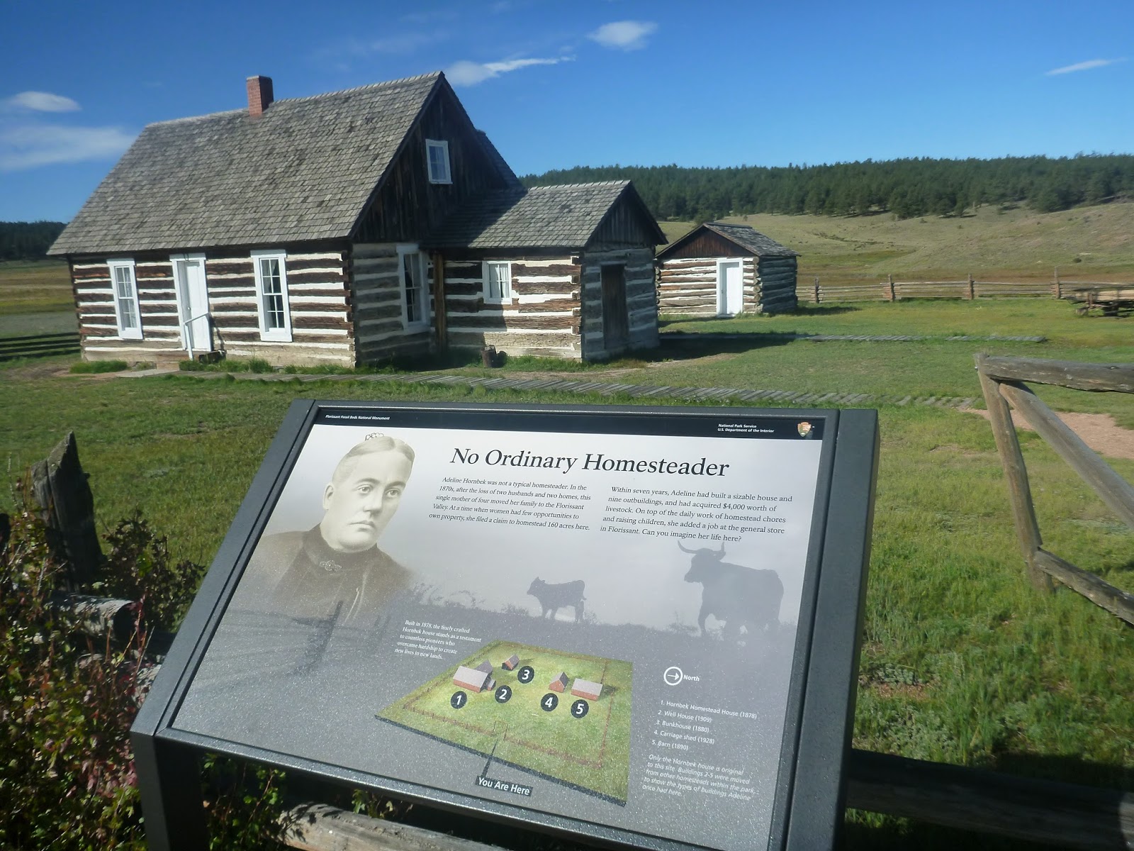
The next morning, I set off south from Denver towards Colorado Springs. In Colorado Springs, I swung to the west and headed up into the mountains. The road was lovely, with aspens showing fall color on both sides of the road. My initial destination was a little blip of red, which on my map is used to signify land administered by the National Park Service. In this case, the target was Flourissant Fossil Beds National Monument.

Flourissant was the site of an ancient lake bed. As a result, the ground here is rich with fossils. This was discovered by a female pioneer. Her husband established the ranch, while she poked around in the woods and discovered she was sitting on a treasure trove of fossils. Writing to other scholars, the location quickly became known and studied. I loved the idea of this young woman discovering a world heritage site in her backyard while her husband ranched away clueless.
The other cool thing that Flourissant features is huge petrified stumps. There are two major sites, one massive one, and then a group of three across the other side of the meadow. What’s funny is that around the turn of the century, two competing resorts opened at each end of the meadow, each controlling access to one of the stumps. They would compete with each other for each tourist who came over the hill. I found the whole history of this place fascinating.
After Flourissant, I drove back down the hill and then took a right up to Pike’s Peak. I didn’t get all the way up, as the peak was closed due to snow after about 11,500, but it was very exciting to be back up in the high country and have a preview of where I was going in a few days.
Finally, I headed south, and swung around the Rockies to camp at the base of the Sangre de Cristo range, at Great Sand Dunes National Park.
This is not a park I would have normally visited (sand dune hiking sounds more fun than it is in reality), but it was worth a visit all the same. Thanks to the season, the mountains were snow-dusted and incredibly scenic towering above the dunes.
I camped in the park and did a little hiking around on what trails were there. This park is similar to the Needles district, it doesn’t see much in the way of visitors and remains dusty and forgotten, just the way I like it.
The next day, it was finally time to start backpacking. But first, I needed to get there, so I took a long drive north from Salida to Twin Lakes, and finally over Independence Pass.
The benefit of taking such a long and winding route through Colorado was that I got to see much more of the state than I had years earlier. On that trip, I’d hiked in the Weminuche Wilderness, which is in the lower corner of Colorado – you can scoot right into and out of it without having to do much driving. But on this trip, I was driving everywhere, and Independence Pass was the highlight of the drive. At 12096 feet, it’s about as high as passes I would be hiking over, and its snowy and windblown scenery reflected that.
I made my through Aspen and to the trailhead. The route I’d selected to backpack was known as the four-pass loop in the Maroon Bells Wilderness. It’s a classic loop hike that connects four high passes and stays in glorious alpine country the entire way. It’s got a reputation as one of the absolute best hikes, in a state filled with best hikes. At only 28 miles, it was significantly shorter than I would usually do on these trips, but a lot would be packed in over those 28 miles. The trail started from Maroon Lake.
Maroon Lake was a wonder. A beautiful lakeshore dotted with aspens in fall color, with the huge snowy mass of West Maroon Peak hulking over all. An unbelievable picture postcard scene. Like Mesa Arch, this is another one of those spots that is so incredibly scenic and very close to a road, so you see it everywhere in landscape photography once you’ve learned to recognize it. And like Mesa Arch, the photo little compares to the actual experience of being there.
There were a lot of people – there’s a shuttle bus from the Aspen ski resort – but thankfully I quickly left them behind as I left the lakeshore and headed into the Maroon Bells Wilderness.
I hiked on a short distance up the trail to a small hill above a lake to camp the first night.
The next morning, I climbed up to West Maroon Pass. This pass was choked with snow and was very exciting to hike up.
The wind was howling through the pass at the summit.
From the highpoint, I dropped down into a valley above Crested Butte. I would be climbing two passes today, so I quickly headed up and over the second, Frigid Air Pass.
The top of this pass felt, if anything, even more remote and wild than the first. I was really deep in the wilderness now. The snow had been the missing element the last two years in Wyoming and Canada – it pushed the day’s trip over from the simple walk category and gave everything the flavor of real adventure.
I dropped from Frigid Air Pass straight down the mountain, eventually picking up the trail again below the snow. As I headed down the valley, I ran into a hiker coming up, who told me to be on the lookout for a waterfall on the North Fork of the Crystal River, further down the valley. Apparently there was a nice campsite directly overlooking the falls.
With his advice in mind, I found the campsite and snuggled in for the night.
The next morning was more of the same. A struggle up above the tree to cross massive 12500 foot Trail Rider pass, with the view becoming more and more jaw dropping all the way up.
Then on the other side, a drop down into the trees and to a spectacular campsite.
The campsite for night 3 was Snowmass Lake, stunning alpine lake with massive walls towering above. The outlet of the lake featured some excellent waterfalls as well. You couldn’t ask for a nicer campsite.
During the night, a huge wind started howling. My tarptent at one point collapsed on me, and in the morning I’d find a bent tent stake. About 2 or 3 am, the wind finally died down and the woods became peaceful and silent. I should have known what the silence meant, but I’d been spoiled by too many years in Arizona.
Snow was still pouring down even after I got up.
The prevailing mood on waking was serenity. A snow storm, in a place like this, is magical. Peace and silence reigned in the snowy woods.
Of course, snow in this quantity, at this elevation, also posed a danger. My next task was to cross a final 12500 foot pass to get back to my car outside Aspen. I waited a bit, but the snow showed no sign of abating, so after consulting the maps I determined that I could follow a trail down out of the mountains to Snowmass Village, and that a hitch from Snowmass back to my car would be possible. I followed the trail down out of the woods along a snowy creek.
I was crossing the creek on a huge beaver dam when I ran into Adam. In that subtle “I’m asking but not really asking” way that most thru-hikers will recognize, I was able to explain to him my dilemma and yogi an offer of a ride to my car from him.
Adam was a seminary student who had moved to Colorado not long ago and fallen in love with the mountain scenery and the practice of bagging 14ers. He had been in the mountains for a long weekend to bag a couple of the more difficult mountains. He had taken off his pack at around 13500 to run up to the summit of a mountain, and on returning could not find his pack. So he spent a very uncomfortable night across the lake from me huddled in a space blanket. In the morning, he had somehow managed to find his pack again under all that snow and headed back down towards his car. We debated whether or not he would tell his wife this story, coming to the conclusion that he had to. It was an awesome adventure story, and he had to tell it, and he would just be asking for trouble to tell his friends the story and not tell his wife.
Safely back at my car, I stopped in Aspen for an expensive lunch before heading south. My goal at this point was to head out of the mountains and spend a few days seeing some of the sights in Colorado. The first destination was the north rim of Black Canyon of the Gunnison National Park.
I’ve seen no shortage of impressive canyons in my life, but Black Canyon was still amazing. The depth of the canyon combined with the sheer walls was something to behold. Grand Canyon is bigger, but the sheer walls of Black Canyon were more impressive.
Black Canyon is in an obscure part of Colorado that doesn’t see many visitors, and most of them seem to go to the south rim. So the north stays quiet. It was the perfect way to see the scenery.

My original plan was to camp at the North Rim, but the snow storm I had woken up to was growing and consolidating. I decided to get down to the lower country on the south rim while I still could. The road takes a circuitous route through the topography, and right around the time the sun set, the skies opened and started dumping heavy snow on the roads. Before too long, I was driving 10 mph with no visibility. This was the worst driving conditions I had ever seen, and I was in wee Ford Focus. I took my time and ended up pulling safely into Gunnison, Colorado around 9 pm. Unfortunately, it turned out that Western State Colorado University was having a major football game that night. I went to the front desk of 5 or 6 different hotels, and all were booked solid. The snow continued to pour outside. Eventually, one of the clerks took pity on me and told me that they were full, but she knew there were rooms at a small motel I had passed on the way into the city. I went back out, and sure enough, managed to snag what I believe was the very last hotel room in town ☺

The next day was a big driving day. I got up early, scraped the ice off my windshield, and headed out. I took a brief detour to visit the south rim of Black Canyon of the Gunnison National Park.
The south rim is the more interesting of the two, and even has a part where you can drive down to the river.
I explored all the overlooks and short trails, then got on the road again.
From the national park, I swung south. I’d head through Ouray and Silverton to Durango. This route would take me over several high mountain passes, and the scenery was excellent.
In particular, the fall colors had hit their absolute peak, and it was a pleasure just to drive around in all that color.
Outside of Durango, I pulled in to the final major stop of the trip: Mesa Verde National Park.
Mesa Verde would only let you schedule one guided trip a day. So I purchased tickets for Cliff Palace that day, and Balcony House the next. After securing a campsite, I drove into the park and joined the group heading down to Cliff Palace.
The ranger was interesting, and the ruins were absolutely astounding.
Cliff Palace is the largest cliff dwelling in the world.
After Cliff Palace, I went over to Spruce Tree House. This is the only large cliff dwelling they let you explore on your own without a guide.
I hiked down and checked out the ruins.
That night, I had a chorus of coyotes to howl me to sleep.
The next morning, before my scheduled tour, I got up early and drove the Mesa Top loop road. I recommend doing this first, if you can. What’s need about the loop road (and neat about Mesa Verde in general) is that it’s got all the major types of Anasazi dwellings, from pit house to mesa top village to cliff dwelling, all in one place. So rather than just checking out one site, you’re forced to consider different types of sites and how they relate to each other. This makes it very easy to trace the evolution of their culture and building style. It’s a great place to piece it all together.
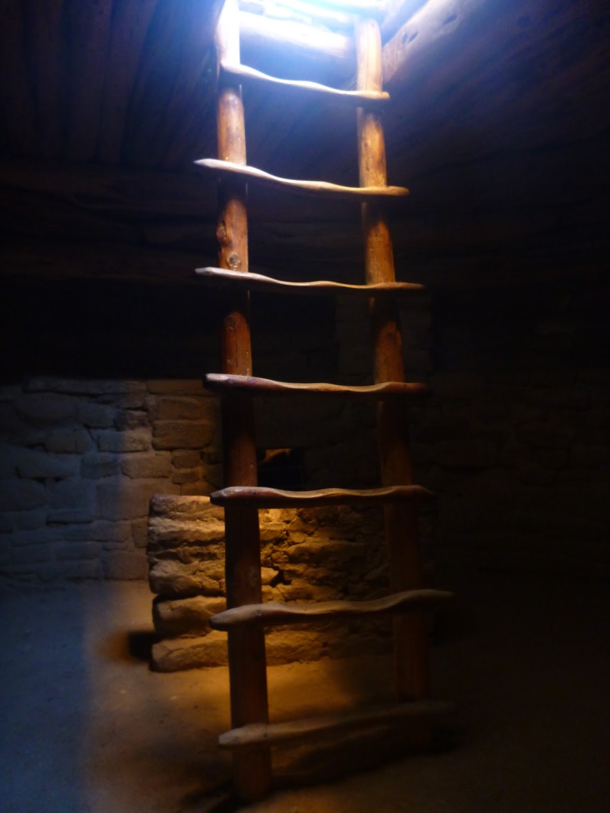
After the loop road, I went on a tour of Balcony House. If you only do one, this is the one to do. Cliff Palace is largely visible from the overlook, but Balcony House is hidden. You have to access it the way the Anasazi did, via ladders leading down from the rim.
At Balcony House, you actually go inside the structure.
It’s incredibly cool. Feels like being in an Indiana Jones movie.
After Balcony House, I visited a few more sites at Mesa Verde before calling it a day.
From there, I headed home. I took a quick swing through Canyon De Chelly on the way, stopping to see Spider Rock.
And around sunset, I took the road through Petrified Forest.
After dinner in Winslow, I took the back roads home.


