Wednesday, October 28, 2015

Great Basin National Park - 2013


Here’s another older trip I’m writing up, mostly because I have a video to go with it.  In the summer of 2013, I wanted to do a trip up to the mountains.  I had a big trip planned to Colorado, but it wouldn’t take place until September, and I was going a little stir-crazy in Arizona.  So I decided to take a five-day trip to see some mountains.  I considered a variety of options in New Mexico and California, before settling on Great Basin National Park in Nevada, mostly because it was another national park to add to the resume, and because I had done zero hiking in Nevada.  
On Day 0, I drove up and stayed at the El Cortez hotel near downtown Las Vegas, mostly because it was only $29/night on a Tuesday night.  I met up with an old friend who had moved up to Las Vegas a few years back and we did the normal vegas routine, drinking it up in some strip casinos and gambling on blackjack.  
Despite the boozey night, the next morning I was up bright and early for the drive up to the park.  Along the way, I diverted over to visit Valley of Fire State Park.  This is a first-rate park with some excellent red rock formations, narrows, slickrock, and petroglyphs.  I did the drive through the park and attempted some brief hikes, but at 100+ degrees I didn’t make it far.  Still it was great to take in the scenery – will definitely need to return in cooler weather to do some more exploring.


The drive up to Great Basin was uneventful, and sooo empty.  Driving around the back roads of Arizona and Utah is action packed by comparison, in Nevada there is nothing out there.  The road unspooled through massive tracks of desert basin between big mountain ranges, usually arrow straight and fast to drive.  After 5 hours on the road I was happy to finally pull into the tiny hamlet of Baker, Nevada, a gateway to the park itself.  In the past few years of exploring, I had grown used to the carnival atmosphere of other gateway towns like Moab, Jackson Hole, or Springdale.  Baker was still a sleepy little small town in the middle of nowhere, with none of the touristy crap that floods similar towns close to national parks.  

I’d find the town’s sensibility reflected in the park as well.  Because Great Basin is so far from major cities – its five hours to either Las Vegas or SLC – the park remains a forgotten outpost on the edge of civilization.  It has not become overwhelmed with the regulations and bureaucracy that have overtaken parks like Zion or Grand Canyon.  There’s no line of cars at a gate to pay exorbitant entrance fees– you pay a few dollars on the honor system by pulling into the visitor center.   It’s possible to roll into the park and snag a primo campsite on a summer weekend without planning six months ahead.  You need not worry about permits for anything other than cave tours – just pull into the trailhead, fill out a form to leave on your dashboard, and off you go.  This is what I imagine visiting the national parks was like back in the 70s and 80s, and it was refreshing to know the experience was still available in some places for those who seek it out.
After snagging a permit to tour Lehman Caves on the last day of the trip, I drove up the park road.  The road winds its way up the ridges of the Snake Range to around 9800 feet at the base of Wheeler Peak.  The views get progressively better as you get higher and higher.  
 
At the end of the road, I reached Wheeler Peak campground and set up camp.  As mentioned before, this camp cannot be reserved, but it rarely fills to capacity.  And it’s a wonder too, with beautiful green meadows and aspen groves in the shadow of alpine views.  


The next morning, I set off with a daypack. There’s a whole network of trails radiating out from the campground, and my intention was to knock them all off in a single day.


The first and primary goal was the summit of Wheeler Peak.  Wheeler Peak is the high point of the park and the Snake Range, in addition to being the second highest peak in Nevada.  I couldn’t rightly visit Great Basin National Park without bagging the summit.


The high up was nicely graded, but a struggle all the same as I gained nearly 3000 feet in elevation.  Shortly after cresting above treeline I passed a group of deer hanging out at altitude.  Silhouetted against the sky, they made for great pictures.


Near the top of the peak, clouds started to roll in.  This was greatly concerning as I was about to be the highest thing around.  I left my metal hiking poles next to the trail and continued up quickly.


The summit sits at 13,065 feet, and the view is vast and far-ranging.  You’re immediately surrounded by the alpine summits of the Snake Range, but beyond that are vast seas of desert.  Having driven through the area just the day before, I knew just how vast and stunningly empty all that territory was.


I didn’t linger on the summit due to the clouds.  I made my way back to my trekking poles and continued on down, back below treeline to the basin at the base of Wheeler Peak.  


I wasn’t done yet, however.  Rather than simply follow the trail back to the campground, I took a right onto the Alpine Lakes Loop trail.  This trail winds through the trees to visit Stella and Teresa Lakes.  Like most alpine lake, the scenery was stunning with the hulking mass of Wheeler Peak towering behind the lakes.


The forest along the trail was wonderful as well.  There’s a certain type of open and airy pine forest that can be found in some western mountain ranges.   I think it’s associated with dry air and somewhat sandy soil.  I first encountered this in the Sierra Nevada during my PCT hike, and (given the context) it has a primal association with wild, beautiful mountain ranges for me.  The previous few years, I had done long hikes in the Wind Rivers and the Canadian Rockies.  While absolutely stunning, these hikes were both in the northern Rockies, which features a much different type of forest just below treeline.  Here, in Great Basin, I delighted to find that open and airy forest of my big adventure again.


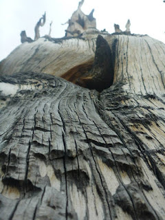
The forest climaxed in a trip up through the Wheeler Peak Bristlecone Pine Grove.  At up to 10000 years old, they’re among the oldest living things on the planet.  Living right at treeline, the trees in this grove had all kinds of personality, with knarled and twisted trunks to adapt to the windy cold conditions.


I pushed a bit beyond the grove to reach the base of the Wheeler Peak Glacier.  This is the only glacier in Nevada.  The brewing thunderstorm finally started as I pulled up the glacier, which seemed appropriate for such a remote and harsh area.  I lingered long enough to take a few photos before turning back.


After a second night at the Wheeler Peak campground, I headed back down the scenic drive for breakfast in Baker.  Today I’d transition from daytrip to a proper adventure.  I headed  over to the trailhead for the Baker Lake trail.  This trail was a pleasant ramble through the woods, six miles up to treeline at Baker Lake. 


While the trail itself was pleasant and easy woods hiking, the scenery got appropriately dramatic at Baker Lake, which nestled in a bowl below scenic alpine cliffs.  I set up camp just 100 feet back from the lake shore, and spent the afternoon reading and watching storms roll over the lake surface.


The morning sun lit up the lake environs. 

 I packed up quickly and headed off-trail up over the divide separating the Baker Lake drainage from Johnson Lake. 

 Pulling down out of the high country for the last time, I picked up the Johnson Lake trail along the shores of the lake.  This trail led through aspen and conifer groves, passing cabins and mining remnants from days gone by.


I missed a junction somewhere along the way, and ended up down on the valley floor, which meant having to backtrack and re-climb about 1000 feet to get up over the Johnson Creek Divide.


Below the divide, the trail rambled through great meadows to reach the Baker Lake trailhead once again.


Before leaving the park, I wanted to visit Lehman Caves.  Lehman Caves was the original tourist attraction here – it was the reason the area became known and the reason it was protected, with the Snake Range serving as a nice bonus.  So the final thing I did at Great Basin National Park was to pull into the visitor center for the Grand Palace cave tour.


Lehman Cave is a beautiful marble cave.  


It’s been well protected and has all of the stalagtites, stalagmites, helictites , popcorn and other features that people visit these places for.


In particular, Lehman Caves is known for having a concentration of rare shield formations.


I’ve not spent much time visiting caves.  I think I saw a few in Ohio during trips to my grandparent’s home when I was a kid, but I’d never visited any as an adult, post PCT-hike when the outdoor obsession bit me big time.  So Lehman Caves was a revelation, a fresh encounter with a type of wild place that had remained unknown to me up to that point.   I’m hesitant to dive into caving as a DIY adventurer – it takes serious know-how, and a tolerance for claustrophobia – but I’d make it a point to visit some other famous “show caves” in the coming years as a result of this trip.


I camped that night outside the park, cutting an hour or so off the drive the next day.  In the morning, I hit the road early and arrived at Cathedral Gorge State Park in the early morning hours.


Cathedral Gorge was a great pit stop on the way home.  The entire gorge is filled with siltstone narrows and formations.


I drove into the park and hiked up into the formations.  It was a different and unique sort of narrows experience than I’d had before.


After Cathedral Gorge, it was time to put the nose to the grindstone and head home again.  A great trip to put under the belt, in an area most people will never visit despite its national park status.


Tuesday, October 20, 2015

Tatahatso Wash


With the coming of the fall season, attention returns to the Grand Canyon.  I’ve had some of the most epic trips of my life the last fall and spring following technical routes from the book Grand Canyoneering, and this year was to be no exception.  On the agenda was a trip that is fast becoming a classic among a select group of specialists – Tatahatso Wash.  Tatahatso Wash is a gorgeous Redwall slot only a few miles downstream from the Silver Grotto.  Its very similar to that canyon, which I did in late 2014.  Tatahatso could be thought of as the big brother to Shinumo.  Everything that made Shinumo awesome is here, but in bigger doses: its longer, the hiking is more difficult, the canyon is much more technical, and there’s a glorious 7 mile stretch of river to float rather than a 1 mile teaser.  


Entering the canyon requires serious work.  You drop in from the rim down an obscure break through the Kaibab and Coconino formations.  The entrance gully requires some stiff scrambling and downclimbing, passing packs in several spots.   


Once you exit the gully and enter Tatahatso Wash, the hard part starts.  The upper reaches of Tatahatso Wash are choked with boulders, and it’s a good 3 hour of scrambling down the wash through the Supai to reach the start of the narrows.


While the scenery and excitement picks up as the canyon enters the Redwall, the difficulty does not moderate.  This canyon has some of the toughest rappelling I have ever done.  


 Every rappel it seemed had a tricky, awkward start, some kind of undercut, a tendency for the rope to pull you into a nasty pendulum, or all of the above.  And all of this was taking place from some fairly marginal anchors. 


 Fortunately, a group of guys I know well went through the week before us, so we didn’t have to spend a bunch of time constructing anchors.  However, the canyon went on and on.   


We kept thinking we’d start hearing the Colorado soon, only to find the technical section stretching on and on with no end in sight.  By the time we actually could hear the river, all of us were beat to pieces and the sun was starting to leave the sky.


But still, for all of that, the canyon was gorgeous.  Absolutely stunning narrows that few have ever seen.  The sun gave the canyon walls a pink cast in some places, and the so-called “organ pipe” room was a stunning finale to the canyon. 
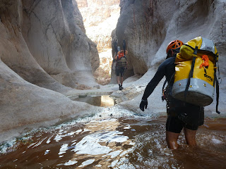


At the end of the day, we rappelled right onto the beach and camped just above the Colorado River.


The next day, our task was to get 6.8 miles around Tatahatso Point to Eminence Beach, the first place we could pick up a trail back to our vehicles.  In order to get there, we inflated packrafts and launched down the river.  


Two of our group had the lightweight Supai rafts, and portaged around the little riffles. 


The rest of us were packing Alpackas, and had some fun running through the rapids.  I managed to flip in the second riffle, as I was wheeling around to monitor the person coming through after me.


Most of the day, though, we just floated along in a haze of beauty.  It seemed almost like cheating to come and do something like this on a weekend trip. 


We exited the river just above President Harding Rapid, and made our way down to Eminence Beach.  I can’t emphasize enough how beautiful this little beach was.  It would have been worth it just to hike down and check out this area.  To have done it as part of such a bigger adventure, was a privilege.


From Eminence Beach, we followed the Eminence Break route up out of the canyon.  This route has a reputation for difficulty, which I found somewhat unearned.  It’s very steep (3000 feet in 2.5 miles), but the route itself is a lot of fun, shimmying along narrow ledges and doing easy little rock climbs.  Its well cairned and easy to follow, and the views back into Marble Canyon are beyond stunning.


The only part that really sucks is the last little bit, up through the Coconino sandstone.  Here, the route degenerates to loose, slide-y scree.  By the time you get here, you are beat up, and the last thing you want to do is deal with a mess of loose rock.  But push through, and soon enough you top out to look back over the adventure of a lifetime! 

Christopher Creek Gorge 2015


Just a quicky. A friend and I got out for one last run through Christopher Creek before it gets too chilly to visit. Christopher Creek is one of the nicest canyons around, with maybe the easiest approach and exit possible, beautiful canyon scenery, and easy and beautiful rappels with flowing water and solid anchors. At the upper end of the canyon, we ran into some SAR folks building a high line for a training exercise, and at the lower end we found a group of freezing teenagers cliff jumping. We also saw some rock climbers putting up new routes at the exit. But we had the technical portion of the canyon to ourselves. Christopher Creek is a true AZ classic.


Alaska Range traverse - Denali National Park


Each year I do a big multi-day trip to a marquee outdoor destination. I was fortunate this year to find even more time to spend outdoors, after an extended stretch in Utah in the spring. My new employer uses a somewhat unorthodox approach of giving you all of your time off days in a lump at the beginning of the year, rather than accumulating them with each paycheck. They also do not roll over vacation from year to year, to encourage people to use their days. So soon after I started in May, I needed to get a big trip on the calendar to chew through the vacation days I got.

I requested the first week of September off without a really good idea of what I would do. After last year’s trip in the Sawtooths, which was almost as much off trail as on, I wanted to continue to step it up. Some friends and I had been talking about a packrafting trip on the Escalante in 2016, and so I bought an Alpacka raft my first month on the job. Pretty soon the destination became clear – ALASKA. I’d visited once before in 1999, but only seen a small part of the state from a tourist’s point of view. Here was a chance to visit the epicenter of packrafting and do the kind of trip that is rarely possible in the lower 48. Seeing that plane ticket prices had dropped like a rock thanks to the extended low gas prices clinched it. Alaska it was. I quickly settled on Denali. Not only because it was THE marquee destination in a state full of them, and another national park to tick off the list, but also because Denali is relatively easy to reach by shuttle bus or train. Most other locations in Alaska require either a rental car or, worse yet, a air taxi to reach. Denali is a great choice to get the full experience without spending a fortune getting to and from the trailhead.

The last weekend in August, I found myself in a shuttle bus heading up from Anchorage to the park. Fall colors were just starting to show and snow had been falling for much of the week. The bus driver called it the first storm of winter – in August! – and referred to it as “termination dust.” Termination signals the termination of summer weather, summer tourists, and for many, termination from their tourist-serving jobs and a transition to some other mode of employment. While the snow made the mountains beautiful, it also gave me some anxiety about my planned route, which crossed over some high passes in Denali. These fears would turn out to be well founded. 
After a 5 hour drive, I arrived at the entrance area to the park. I secured my permit, but the ranger warned me about conditions on the high passes. I grabbed a campsite at Riley Creek (the developed campground at the park entrance) with a ticket for a shuttle bus the next day. For those who visit the park after me, here are a few tips on the permit process and the logistics around the entrance:
  • You’ll get permits from the Backcountry Information Office, which is right next to the Wilderness Access Center where you make shuttle bus and campground reservations. Go to the BIC first, then to the WAC (pronounced “wack” by park employees).
  • No permits are given ahead of time, you have to snag them when you arrive. Few areas were totally full, and I had no problem getting the itinerary I had planned on. It made it easier that I was travelling solo, as each unit is limited to 5 people. A group might have more problems than I did.
  • It’s much better if you do your research beforehand and come to the park with a rough itinerary in mind. I heard the rangers say multiple times over that they couldn’t recommend hikes. They really try to stick to an ethic of self-reliance and letting hikers choose their own adventure, and make their own mistakes. The issue is that the whole “no permit til you arrive” thing means a lot of people show up at the BIC with absolutely no plan in mind, expecting that the rangers will tell them the best places to go. I witnessed a lot of pissing and moaning as people tried to work out a route on their own, and a lot of people ending up choosing units that I knew (from research beforehand) were boggy, low elevation, or not the most scenic. The rangers would just smile and give them the permit. So I suggest doing research before you go. The backcountry unit descriptions found online give great detail on topography and attractions in each unit. By reading between the lines you’ll see which units are better (more scenic, easier to navigate) than others. The descriptions also offer suggestions on routes, and will tell you, roughly, how to connect one unit to the next. With a map and the unit descriptions in hand you can work out a solid itinerary. If you go into the BIC with a rough itinerary in mind, then the rangers will give you vastly more useful information, telling you that X-pass from unit 1 to unit 2 is brushy, and this alternate would be a better route. Save yourself some headache and plan ahead, for sure.
  • Most backpackers are going overnight or two nights out at the most. The third night and beyond, everything was available. So if you are planning a longer trip, be flexible on the front end, and after the first day you can define a more rigid agenda. For me, I planned to start in Unit 9, but I planned routes starting in Units 10, 9, and 8, and then entering Unit 9, to give myself max flexibility for the first day or two. As it turned out, I didn’t need the alternates and just started right in Unit 9, but having the backup plans was a good idea.
  • I didn’t run into any rangers out in the backcountry. In fact I didn’t run into a single person at all. While you probably need to start where your permit says (the shuttle drivers didn’t check, but they could), once you get into the backcountry you’re mostly on your own.
  • The backcountry office supplies free Garcia Machine bear canisters, in regular and large sizes.
  • The mandatory video before you get your permit is actually really helpful. It gives the standard advice but also covers scenarios I hadn’t thought of, like what to do if a bear approaches your camp while you are in the middle of cooking. It’s one of the better overviews of hiking in grizzly country and doing large stream crossings that I’ve come across.
  • Riley Creek campground is walking distance from the WAC. There’s also a free shuttle. There are plenty of walkin tent sites at the upper end of the Caribou loop. Get your permit for these sites at the WAC (not at the Riley mercantile), at the same counter where you get your shuttle bus ticket.
  • The Riley Creek mercantile has showers and a laundry. The laundry didn’t get my attention at first since I usually just carry my dirty clothes home with me. However, it is incredibly useful because Alaska is wet, wet, wet. Even if it’s not raining or snowing, just walking through the tundra your shoes and socks will be soaked. While I didn’t wash anything, I used the dryers multiple times over so I’d have dry clothing and a dry tarp to sleep under. Bring a roll of quarters, or lots of $1s to exchange for quarters. I had a lot of fun “hiker trashing” up the patio at the Riley Creek mercantile like the good old PCT days
  • There’s a free shuttle that runs between the WAC, Riley Creek and the visitor center compound, but there are also trails. I mostly walked the trails, and there’s some lovely scenery and things of historical interest to see. The Jonestown trail is worth noting since it runs from Riley Creek into town. There is no regular shuttle from town to the park entrance area, though some hotels run shuttles if you are a hotel guest.
  • There are limited food options in the park. The Riley Creek mercantile has convenience store food and a microwave, and there’s a small coffee shop and limited cafeteria near the visitor center. The best food options lay in the town, which is about a 15-20 minute walk down the Jonestown trail. This walk is worth doing at least once since you cross the scenic Nenana River and get to watch the kayakers and rafters in action.
  • The town is mostly the usual collection of tourist junk shops and a few nicer artisan souvenir shops, along with restaurants and hotels. The lodging situation is unfortunate. There’s only three hotels in the town that are walking distance to the park, and all of them are expensive. Two are resort style places that I didn’t even look at – the names/titles made it clear they were out of my price range. The Denali Bluffs Hotel is the only non-resort, and mid-week, just out of the summer season, it still ran about $260/night There’s some other less expensive lodging options including a hostel, but all are 10+ miles from the park entrance, much too far to walk. Some might offer shuttle services, but I think Riley Creek is the best all around option for walkers.
  • There’s a free courtesy phone on the back porch of the WAC. There’s a list of contact information for all the nearby lodging and some other businesses. If the lodging operates a shuttle this could be a good way to get there.
  • They do not sell bear spray or stove fuel in the park entrance area. You will need to go into town and get to Denali Mountain Works to purchase these items. This store has any last minute gear items you might need. You might also ask hikers on the porch at the Riley Creek mercantile, as many of them leave their bear spray behind when they leave the park,as they can’t take it on the plane. I bought mine but was later offered some for free.
  • There isn’t really a good place to get food for the trail. The stores are all tourist junk shops and gas station type places. You could probably cobble together a resupply out of gas station food plus some freeze-dried meals from Denali Mtn Works, but it will be less than ideal, and at Alaska prices. Much better to bring your food with you to the state.
  • Make sure you allow enough time in your itinerary for the shuttle bus. I underestimated this ride. It can’t be emphasized enough how long that shuttle lasts. Going all the way to the wonder lake area will take around 6 hours, one way. Even getting to areas around the entrance like the Sanctuary or Teklanika rivers will take more than an hour. It’s just a big-ass park. The drive is scenic and you’re likely to spot wildlife, so it’s an enjoyable ride, just make sure you are making allowances in your itinerary for just how big the park is. For wildlife sightings, there’s a flat area before the Savage River crossing that often had moose, and the Igloo Creek area frequently had grizzlies.
  • There are lockers at the WAC. This is incredibly useful for a person on foot, since you can bring stuff with you that you don’t have to carry into the backcountry. For instance, you could bring a duffle to store your pack for the flight, or a change of clothes for after the hike. If I had known about the lockers, I would have brought a separate carry on with some luxury items. The lockers cost 50 cents per use – bring quarters. Note that’s per use, not per day.
  • When you are travelling out after your hike, you can hitch a ride on any green bus (that has room). You are also welcome to try sticking out your thumb for the other buses – I got turned down by a few of them, but one picked me up and took me out to the entrance, so I think it varies based on the driver. But worst case scenario just wait for a green bus.
Okay, that went on way longer than anticipated, but I’m glad I got it typed up. I found it hard to find information online about the entrance area and all the logistics of hiking at Denali before I went, so I had to work most of this out when I got up there. This is all the stuff I wished I knew, so hopefully it proves useful to someone.
My second day in Alaska, I had all my logistics wrapped up nicely and got on a shuttle bus heading down the park road. All of the scenery was dusted with snow and the drive in was incredible scenic.


At Igloo Creek, we saw a sow grizzly with two spring cubs right next to the bus.

Finally, after about 3 hours, I was dropped on the side of the road in the middle of nowhere. A short bash through snow covered brush delivered me into a gully that led down to the main fork of the Toklat River, where I’d start my hike.

Hiking up the Toklat was delightful. The hiking up a large glacial flood plain was open and easy, and the surrounding ridges were all dusted with snow from the last few days. The snowy mountains kept going in and out of view as clouds and fog opened up to reveal the views, and then closed in. Despite the cool temps and snow on the ridges, no precipitation fell and I had an easy walk up the flood plain into the deeper recesses of Unit 9.


After crossing a braid of the infant Toklat River, I set up camp right out in the open on a large pebble plain. I figured this would make it tough for a grizzly to sneak up on me out in the open like that. I had hoped prior to the trip to pick up a pyramid style tarp shelter, which I think is the best choice for these sorts of conditions for their wind- and snow-shedding profile. However it was simply too much expense after picking up an entire packrafting kit and a delorme satellite messenger. So I used my old reliable Tarptent Squall 2, with the intent to get the ‘mid next time I plan a journey into big alpine country. After my tent stakes bent during a blizzard in the Maroon Bells in 2013, I was taking no chances. I staked out both groundsheet and tarp, then buried the stakes under rock piles to stabilize them.


It ended up snowing that night, but lightly. I had to knock the snow off the roof a few times, but otherwise had no problems. Around 2 am, I got up to pee. Fog had poured into the valley of the Toklat, and thanks to a super-moon, all the fog and the surrounding peaks (what I could make out of them) were lit up orange. It was an eerie, otherworldly sight, and I felt profound gratitude I had the privilege to see it.

The next morning, everything was covered in snow. Granted it had been snowy the day before, but the valley floor had been relatively clear. Now everything was coated. It was clear that winter was fast approaching. I set out to try to cross over into Unit 8. My originally planned pass was way up in the left branch of the headwaters, and required a near 3K elevation gain. I dismissed this possibility out of hand given the conditions.
After reviewing the map, the first route that looked feasible was not quite as far back into the unit, and would require about 1200 feet elevation gain. I set off up a creek towards this pass.


As I got in closer, everything was covered in snow, but there were small patches of rocks, and the slope looked maybe gradual enough that I could get up. 

I plowed up the first 500 feet of elevation gain. Travelling on the rocks was not as good as it first appeared. Rather than solid ground, the “rocks” were loose and crumbly scree and dirt that would shift and crumble underfoot as I got my weight onto it. Much of the scree was also covered with a light layer of ice and snow. I quickly gave up on the rocks and started plowing directly up the snowy sections. This was not as crumbly as the scree, but each step took major effort. I was breaking my own trail through the snow, wallowing up to my waist at time, which is majorly different than walking a snowy trail that’s already been treaded down by other hikers in front of you. To make matters worse, the slope changed as I got higher, approach a 40-50% slope at times. Eventually, I pulled out my GPS to check my position, and realized that I had to go even further up that I first thought, and was only about 1/3 of the way up rather than halfway as I thought. Between the effort being expended and the constant danger of slipping from either snow or crumbly scree, I finally threw in the towel. This route was not going to work. I turned tail and headed back out the way I came. Going down was much easier than going up and in an hour I was back in the valley of the Toklat River.


I headed north (downstream) looking for the next major pass. Unfortunately I had to go nearly all the way back to close to the road to get there. But eventually I started heading up towards a likely-looking passage. The going was relatively easier this time being below the brush line, but still a ton of work, bushwhacking through willows and treading snow covered ground.
As I approached the pass, I crested a hill and found myself staring at a giant canyon between me and the pass. What had looked like a relatively easy jaunt uphill was going to be a major effort, and I still wasn’t sure if the other side of the pass would “go” or not. I checked my GPS, which of course, now that I knew it was there, showed the canyon clearly. Swearing colorfully, I headed back down into the valley of the Toklat.

Things were getting a little dire. It looked like the only likely passage through to Unit 8 would be almost next to the park road. And it was going on 4 PM at this point. Though I was tired, the sun wouldn’t set for another 6.5 hours, so I decided to try to press onwards to see if I could salvage my schedule.

I climbed back up out of the Toklat valley and onto hillsides leading into Unit 8. It was clear this route would offer passage, but not easy passage. As I got onto the hillsides, I had my first real encounter with tussocks. Tussocks are mounded clumps of spongy vegetation. They’re important to Alaskan hiking because they can transform a route that looks like flat easy passage into a nightmare. They are exhausting to walk up, down and over. And that’s quickly the state I found myself in. Each step I took would sink 2-3 inches into the ground, and the topography of the ground would constantly shift. It was the worst cross-country hiking I’ve done, worse than walking on sand.
After a few hours wading through this mess, I had barely started to approach the border of Unit 8. I stopped to take stock. I could, if desired, make it into Unit 8 before sunset, but just barely. The problem was, I was within sight of the park road. Not exactly the wilderness experience I had come to Alaska to seek out. What’s worse, reviewing the map, that seemed unlikely to change. The route I had planned originally had crossed from unit to unit via high passes near the headwaters of each unit. I knew this plan was ambitious when I made it, but no day was over 8 miles or 3K elevation gain. Most days were around 1-2K gain except for the first day.
However, while an itinerary of this type would be very achievable in the lower 48, even off-trail, it was overly ambitious for Alaska. And with the snow, the passes I planned on were impassible. I’d need to re-route over a bunch of low passes. The map made it appear that the only feasible “low pass” route from Unit 9 to Unit 6 would leave me paralleling the park road the whole way. Once at Unit 6, I could turn and head up to get away into the wilderness. This route would be longer mileage-wise than my planned itinerary, leave me in boggy brushland rather than the high country I hoped to see, and I would be relatively close to the road the whole way. I finally decided that I need to regroup and really re-think my itinerary. I hit the road, flagged down a bus, and made it back to the entrance area of the park around 9 pm.


To revive my flagging confidence, I decided to splurge on a night in a hotel rather than another night at Riley Creek Campground. Fortunately the “cheapest” hotel in town, the Denali Bluffs, had openings, so I secured a room using the courtesy phone at the WAC. I had a nice dinner, used a dryer at the hotel to dry my snow-soaked tarp and shoes, and zonked out for the night.
The next morning, I headed back to the park on a mission. I had reviewed the online unit descriptions again with map in hand the night before. I recalibrated and picked a route that would be feasible under the current conditions, and would still allow me to finish up with my planned packraft down the Sanctuary. I went back to the BIC and revised my permit. My new itinerary would involve hiking up the Teklanika River, crossing a low pass north of Double Mountain into the Refuge Valley, and spending a little time exploring the Refuge Valley before rafting out on the Sanctuary. The ranger validated that the ridge separating the Tek from the Sanctuary should be crossable and relatively snow free, if brushy. I snagged another camper bus ticket for that afternoon and got on the bus. After a relatively short 1.5 hour ride I was dropped off at the bridge over the Teklanika River.


The Teklanika was wonderful. Another wide open valley with a huge glacial river rushing through it, just like the Toklat in Unit 9. The willows in the valley were blooming with fall color while the peaks lining the river valley were snow covered. This was the kind of stuff I came here to see.


Further to the north, the Teklanika picks up steam and becomes a major river cutting through the park. Its actually the same river that trapped Chirs McCandless at the “magic bus,” which eventually lead to his death. Here, near the headwaters of the Alaska range, the river was small but boisterous. If I failed AGAIN to get over a pass, the Teklanika looked like it might present a good alternative packraft.
I made my way only a short ways up into the valley of the Tek, basically far enough to be out of site of the park road, before setting up camp for the night. 

The next morning, I continued on up the valley toward my planned passage. As I bashed through the willows, I saw the furry brown hump of a grizzly bear! He was only about 60-80 feet away from me, and I was in a nasty position, where to back away from him would have required jumping in the river. As it was, I froze, and he either didn’t notice me, or more likely decided to ignore me, and passed by before melting into the willows. This was my closest encounter with a grizzly on this trip, and what a thrill!


Soon after my bear encounter, I clambered up a slope and started heading into the forest, bound for the pass I had identified. The trees were thick, the ground was spongy, and there was absolutely zero sign that anyone had ever passed this way before. Its hard to overemphasize just how isolated this whole thing felt. This was SERIOUS wilderness, of a kind I have only rarely encountered in the lower 48. 

Eventually, I intersected a creek, and followed it as it ascended above the brushline towards the pass. Once out of the forest , the hills were lined with blueberries, and criss-crossed with bear trails. This made for much easier walking than bashing through the brush. I yelled up a storm on my way up and didn’t have any animal encounters.


Eventually, I topped the pass, and looked down on the Refuge Valley with the Teklanika River flowing through. Like most alpine passes, the view in both directions was spectacular, and enhanced in this case by how incredibly remote the whole thing felt.


I made my way down from the pass, happy that a route I had worked out on paper proved to be a viable route through the mountains. Shortly below the pass, I hit a nice rocky stretch that provided a break from the walking. I happened to pull out my satellite messenger to check the time, and realized it was past 6 pm! I set up camp, not far below the pass. Looking at the map, I made a grand total of about 3.5 miles that day, which would be hilariously pathetic on a normal trip. I was satisfied with my progress though, which should go to show exactly how much you have to adjust your expectations for Alaska.
The next day I continued down into the Refuge Valley. The going was if anything even more arduous than the previous day. While the downhill made things easier, the going frequently dissolved into huge bogs. I initially tried to find ways around the bogs, but most of them were too huge, so the usual way was straight through. At times I sunk up to my waste in water. 
 
After a half-day plowing through terrain like this, I finally climbed down a bank and into the Refuge Valley. Like the Toklat and Teklanika, this river valley was also much easier traveling, on firm gravel bars.


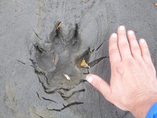
The mud and soft ground along the gravel bars also made it easy to see that the Refuge Valley was practically swarming with wildlife.
Shortly after getting down into the Refuge Valley, I set up an early afternoon campsite next to the Sanctuary River.
The next day, I had a full day to kill. So I finally got to leave my heavy pack behind. I strapped on a light day pack and hiked up the valley.

The hiking was along the Sanctuary River, and I had a constant choice to hike up high on the river banks, which was usually arduous and required walking over spongy tussocks, or hiking next to the river, which offered easy walking on firm gravel bars, but necessitated frequent crossings of braids of the river, and also killed visibility. Hiking next to the river often meant bush bashing through willows, and the risk of an animal encounter was high. On the whole, I tended to stick to the easier hiking along the river when I could, making lots of noise to warn animals I was coming.

I travelled far upstream before turning back. As I was coming back, I was tucked behind a low ridge when I saw movement ahead. I ducked down, and the movement came into focus as a caribou approaching my position. Eventually he smelled me, and diverted to cross the Sanctuary River. I got some great footage of him crossing and was grateful to have a low-stress animal encounter to add to the experience.


The next day was the final day. I got up in a state of incredible excitement. It was packrafting time! I had come all the way to Alaska, invested a good deal of money in kit, and carried a heavy-ass pack for the past 7 days, just for this experience. My previous two days camping and hiking along the Sanctuary River had only increased my excitement. The river was fast and swirling, a huge contrast to the big, slow, practically flatwater rivers I had travelled on in the Southwest. I actually had to scout around a bit to find a eddy that was slow enough I could get into my boat safely. But quickly enough, I did, and I was off!

The upper parts of the river were challenging. Several times after I put in, the river braided out, and it was always guesswork trying to figure out which channel would be deep enough to go. I bottomed out more times that I can count actually – which only goes to show how amazingly tough the Alpackas are. After the first few braided sections, I got a little better at picking which channel to use.
The river was fast, cold and swift. I had a cruiser deck on my Alpacka, and wore raingear plus neoprene gloves and socks. I also brought my sleeping pad inside the boat with me, to insulate the floor from the glacial water. This worked well enough at first, but there were some wave trains that slopped water inside the boat, including one memorable moment where I got hit by waves from the side as two channels merged. After the first two hours, I was sitting in a pool of cold water and my bottom half was soaked. This could have posed a real problem if I hadn’t been rafting out to a road and safety. I had extra warm clothes that I had kept inside my pack, in trash compactor bags, and they ended up staying dry. But it still would have been tough to get done rafting and then have to deal with half my clothing being sopping wet. This bears a little thought for future packrafting trips. I think a drysuit would be ideal, if heavy.
Still, the trip was fun, fun, fun. Lots of little rapids and wave trains. No intimidating whitewater, just pure fun. The only sketchy moment was when I got swept close to some trees at the river side, but I was able to duck under and push off with no damage. The only real disappointment was that my jury-rigged “camera-to-gopro adapter for head mounting” backfired. The setup worked, but I failed to aim it correctly, so I took a bunch of video of the sky instead of the water.
After about 3 hours rafting, the bridge for the park road came into view. I pulled off to the side, changed back to dry clothes, and packed my sopping wet bundle up. After a few hours, I hopped on a green bus and headed back to the entrance. A train ride later and I was back in Anchorage, tired but completely satisfied with the experience. Time to start putting more Alaska trips on the calendar!