Happy to post a new trip report rather than raking over historical trips this week!
After many weeks at home due to family obligations and various injuries I had a serious case of canyon fever. I was invited to Parker Canyon, but had to be on-call Saturday morning. By 10 am I was off the hook, but my regular canyoneering partners were all out at Parker already, so I needed something I could do solo. I contemplated some of the shorter trips in the Supes like Headdress, but given that I was still recovering from a back injury also, I wanted to do one I had done before. So El Capitan it was. Paying $1.67 a gallon also made it much easier to decide to do something farther out.
On the approach, I was huffing and puffing up the hill to get to the entrance gully, when I looked over my shoulder to see a huge group of bighorn sheep!
I've seen bighorn before, but never such a big group, and never so up close. They were maybe less that 20 feet away and perfectly silouetted against the far off mountains. Unlike the bighorns I'd seen before, these ones also didn't take off right away. Instead, they carefully trotted past me and up the mountain. My path continue to cross theirs, and they'd eye me carefully, moving to accommodate, and continued to "dance" with me up the mountain until I finally pulled ahead and left them behind. One of the best wildlife encounters I've had in awhile!
The canyon itself was as great as it was the first time around. This time I had a helmet mount for my camera, though its placed a little high so not as easy to capture good footage as a gopro. But it seemed to work.
El Capitan is an underrated canyon in my opinion. Easy entrance and exit and really first rate narrows. The rappels are not too exciting - five, and only two of them over 10 feet - but that's just the ticket for a solo trip. It was just nice to be back out in some good scenery, and to have it all to myself.
As some friends like to say, a great day to be in the canyons!
In 2011, my girlfriend and I visited the North Rim of the Grand Canyon, and in 2012, we visited Page, AZ and Zion National Park. These were all places I had been to before, but it was wonderful seeing it through someone else's eyes. Wanting to continue the tradition, in March of 2013 we took four days off to take another swing through Southern Utah.
Our base of operations was Ruby's Lodge just outside Bryce Canyon. I had visited Bryce by myself for the first time just a few years before. That trip was also in the winter months, and I found the park absolutely magical. I had been going through a somewhat tough time in my personal life, and being out among those red rocks dappled with snow was transformative. The roads to Bryce are kept plowed through the winter, and the trails stay more or less accessible (especially with some traction devices), which makes winter hands-down the best time to visit the park. The crowds are a fraction of what you have to deal with in summer, and the snow only adds to the scenery. Just as with the Grand Canyon, winter is the time to go.
The actual trip was pretty much like any other Bryce trip. We walked the rim trails at sunrise:
Sunrise and Rim Views
We drove out to the last pullout, then drove back, stopping at each viewpoint along the way:
Hoodoo up close
We saw deers in the meadows along the drive:
About mid-day, once we had visited each of the viewpoints, we went to Sunset Point and hopped onto the below the rim trails. This time, we were able to do the peek-a-boo loop, which had been snowed in the last time I visited. The trails at Bryce pack some of the best scenery I've seen on any short hike. They rival Antelope Canyon or the Zion Narrows for effort:reward ratio:
Along the Peek-A-Boo loop
After a full day at Bryce, we decided to take a day trip out to Capitol Reef. This was not exactly convenient, requiring a couple hours drive out and a couple hours back. But we had already visited Zion the year before, and the scenery on that drive more than compensated:
Snow on Boulder Mountain
Arches along the trail to Calf Creek Falls. Unfortunately we did not make it all the way out to the falls this trip.
The long road trip meant that we only had a few hours to enjoy Capitol Reef, which was in no way enough time to do justice to such a beautiful place.
Juniper and Waterpocket Fold
We did the unexpectedly amazing drive up Capitol Gorge, then hiked on up the Gorge and to the water pockets. Along with stopping at some view points and some other small hikes, it was about all that we could squeeze in. In the back of my mind I made a mental note to plan an extended backpack up here. Given the remoteness and the scale of the park, this seems like the best way to visit. But we still squeezed as much enjoyment out of the hike as we could given what time we had.
Hiking Capitol Gorge
View of Capitol Gorge from above
Sunset at Powell Point, on the drive back
The last morning at Bryce was beautiful, as always. We hiked the rim trail from Bryce to Inspiration Point, watching the rising sun light the formations. On our way out of the park, we pulled off a large meadow to see herds of pronghorn. It was a fitting goodbye to Bryce.
Hoodoos and Light
Pronghorn in the meadow outside the park
One of the advantages of visiting a region multiple times is that you can see the little pockets of interesting sites. We had visited Southwestern Utah several times now, so we could spare a little time to see sights that were not marquee attractions, but worth visiting all the same. On our last visit, we had squeezed in a trip to Coral Pink Sand Dunes State Park, and intended to do similar this time around. On the drive up, we visited Moqui Cave, a tourist trappy private attraction on the road to Bryce.
Inside Moqui Cave
On the drive back, we stopped at Best Friends Animal Sanctuary, though we missed the opportunity to take a tour. We made it up with a detour over to Pipe Springs National Monument after crossing back into Arizona. Pipe Springs was the only reliable water source on all of the Arizona Strip, and so was a hub of Mormon society in the area. The park service has preserved the buildings surrounding the spring. While I would never consider driving across the state just to visit Pipe Springs, it was very interesting to learn about the Mormon pioneer days, and well worth a side trip while in the area.
I will admit, prior to 2013, I had not done much hiking in
the Grand Canyon. A few little day hikes, some exploring of the Marble Canyon area, and that was about it. My excuse for this shameful behavior was that it always seemed like simply too much of a hassle. Huge
elevation changes, permit hassles, crowds of people. There were always other options that were more appealing.
However, several factors came together that started to
change this perception. I was contemplating the possibility of moving to
Colorado or somewhere else. I asked myself what would I regret if I
left Arizona, and not hiking more in the Grand Canyon was the first
answer to come to mind. More importantly, Todd Martin's book Grand
Canyoneering was published, and it was a revelation. I had always enjoyed exploring slot canyons, especially multi-day ones like Wet Beaver or Tonto Creek where you could really immerse yourself in the canyon environment for days on end. It was kind of a head-slapping "duh" moment to read through grand canyoneering and realize there were hundreds
of multi-day canyon adventures, in one of the greatest parks
in the world, right under my nose. I started getting really excited reading up on how Todd and his hiking partners had used technical skills and packrafts to really open up the grand canyon backcountry. I wanted in. I decided it was time to get serious about the Grand
Canyon.
I scheduled a hike with a meetup group as my first
overnight foray into the canyon. The chosen trail would be the hermit
trail. This was a perfect choice, as it was a scenic non-corridor hike,
with a small slot section at the end. It was a nice sampler of what the Grand Canyon could offer, away from the main routes but still easy in terms of navigation and finding the way. I started hiking up Camelback, and once Camelback closed for renovations, Squaw Peak, on an almost daily basis, building up fitness for those big ascents and descents. In retrospect I overprepared for what was a relatively straightforward overnight, but it was great to get back into "trail shape" and have a body that was capable of chewing up the miles.
As the weekend approached, a winter storm rolled in. Fortunately everyone in attendance was game to hike in the snow, so we piled into cars and headed up to Mather campground on Friday night. It snowed all night and we woke to a winter wonderland. A short drive over the hermit road and we headed down into the canyon.
Heading into a winter wonderland
The first thing you register when hiking the Grand Canyon, especially when you get away from the corridor, is the layers. Like many, I had read the placards on the rim describing the different geological layers the canyon cuts through. But the ground truth reality of those layers only really sinks in when you're trying to hike into the canyon. From the rim, its just colors and stripes. On the trail, however, each layer has its own character and implications. Coconino sandstone means cliffs and big ascents and descents. You've got to find a route through this layer or you risk getting cliffed out. Supai sandstone means ledges and gradual descent. You can contour for miles by using the Supai. Redwall limestone means cliffs again, and if you're lucky, slot canyons. Some of the best slot canyons in the Grand cut through the Redwall. The geological layers become a giant puzzle that you're trying to figure out the best way to pass through.
Canyon layers
That sense of progress on an epic scale was exacerbated on this trip by the weather. On the rim, we progressed through driving snow, that became hail, sleet, rain, and mist as we got lower and lower. Fortunately, we had a group of good hikers, who smiled and laughed through the conditions rather than complaining. This made a huge difference in how enjoyable the hike was.
Epic Weather
Once we reach the Tonto Plateau and Hermit Camp, the trail dropped into a set of narrows. This was the part I had been looking forward to the most, and it didn't disappoint. The slot section was brief, but extremely pretty, and all the more enjoyable by the fact it was surrounded by this vast wilderness. If this was what grand canyoneering would be about, sign me up!
We ended the day camped along the Colorado River next to hermit rapids. For all the epic conditions on the descent, the weather along the river was pleasant and mild.
The climb out the next day turned out to be no problem. It was a long climb out, but not a big deal with all the prep I had done. Each person headed up at their own pace, and as a consequence I had some nice solitude all the way up. The snow came back in full force as I got to the Supai layer, and by the time I reached the rim it was a full-blown blizzard. We crawled back to Phoenix that night at a snail's pace, but got home safely. All in all, an amazing introduction to Grand Canyon hiking!
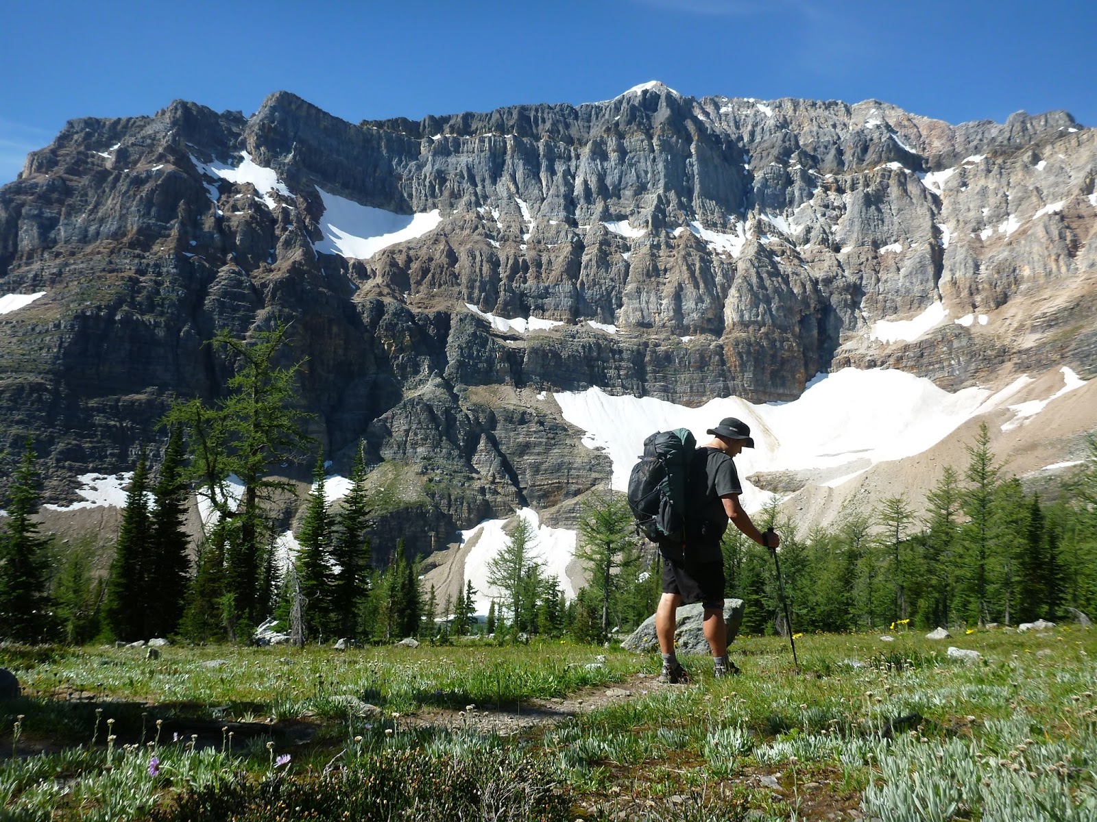
In late spring 2012, I was doing some work for a long-standing client in Saskatchewan. Normally, I'd fly through Denver, but recently WestJet had started offering some routes through Calgary. As I passed through the Calgary airport, I passed a window display showing a photo of the Canadian Rockies. This lit a fire in my belly. I'd been casting about looking for a big trip idea for 2012, and wanting to top 2011's Wind River excursion. Having bought the ticket to Saskatchewan, I realized a trip to Calgary was not unaffordable.
Within a week, I was juggling multiple guidebooks from Amazon, piecing together a route through the heart of Banff and other mountain parks. As quickly as I could I put in for a permit, and was approved. Only after getting the permit did I pluck a GDT guidebook off my shelf (bought long ago, when the thruhiking bug had bit me), only to realize I had re-duplicated the route of the GDT. It was a spectacular route, piecing together 170 km of trail through the heart of Mt Assiniboine, Banff and Kootenay.
It required juggling all sorts of logistics. I'd need to use a combination of shuttle bus, taxi, and hitchhiking to get to and from the trailhead. I'd need to arrange airline tickets and hotel rooms for before and after. I'd need to pick up supplies in Canmore that I couldn't fly with. 10 days of food needed to be bought and packed. It was the most logistically difficult trip I'd planned since my thruhike, but the logistics came together surprisingly easily, and in August I was off to Canada.
The taxi dropped me at a remote trailhead on the edge of Banff. This was fully committing in a way I hadn't experienced in some time. Most trips I took were loops, meaning I could and sometimes did cut them short rather than completing the full loop. That option was not available to me now. I had no car to bail out to, and even if I did, I'd have to wait until my plane ticket out anyway. Bailing was not an option, so here I was, a foreigner in BIG wilderness, with nothing but 10 days of backpacking stretching in front of me.
I'd follow Bryant Creek 9 miles in the first day to the first camp. Bryant Creek was not all that scenic, but just being out in deep forest WAY different than the terrain at home was amazing. It was made all the more spicy by the fact that Bryant Creek is one of the three prime breeding areas for grizzly bears in Banff. This was my first time hiking in grizzly territory, and I was both thrilled and terrified of the possibility of running into one. I must have cried out "hey bear" every 2 minutes that first day. I'd later relax as the trip continued, not yelling out so frequently, but I never lost the awareness that this was serious wilderness, where man was not at the top of the food chain.
(I wouldn't actually encounter a bear on this trip, a fact which brought relief along with a small tinge of disappointment. I would, however, hear wolves howling across two separate lakes).
The other thing that happened the first day was that I split my hiking shorts when bending over at a rest stop. This doesn't sound like a big deal, until you realize that like most long-distance hikers, I tended to strip my load down to the bare minimum necessary. In this case, that mean one shirt and one pair of shorts. I stopped to sew them up, a task I would repeat each night, getting more talented at sewing as each night passed. The shorts ended up holding out for the entire trip, but barely so.
The next day, the trail climbed up into the high country for the first time, climbing over Wonder Pass to enter Mt Assiniboine Provincial Park.
Mt Assiniboine was absolutely stunning. Called "the Matterhorn of the Rockies" for its distinctive, pyramid-shaped peak robed with glaciers, the mountain and its environs was home to some of the finest alpine scenery I've ever seen.
I ended up spending two nights in the park. The beautiful lakes, summits, and scenery were too good to rush through. I climbed Nub Peak on the layover day, which afforded even better views of the park scenery.
Eventually, it was time to leave the idyllic area around Mt Assiniboine, and start to really grind out the miles. I headed north, back into Banff National Park, climbing up over Citadel Pass and to Howard Douglas Lake in a rainstorm. This would be the only inclement weather of the trip.
I passed near a ski area the next morning, which afforded me the opportunity to detour down to a little restaurant for the first fresh food in five days, and a cell phone call to my girlfriend (now wife). From the ski area, I continued on over Healy Pass, into the heart of Banff National Park.
Healy Pass delivered me to the Egypt Lakes area. From there, I climbed over Whistling Pass, named for the numerous, huge marmots that populate the area.
From Whistling Pass, I descended to Haiduk Lake, where I spotted a bald eagle cruising the currents of air above the lake. From Haiduk, the trail descended along a string of lakes. It was an endless procession of marvelous scenery, and I had been out long enough now to slough off the worst of the harried, stressed thinking that you pick up when you spend too much time in the city. I was "walking with beauty," as the AT thruhikers call it, cruising along without a care in the world, open and free.
Eventually, I arrived at Ball Pass Campground, where I had a choice. In the national parks of the Canadian Rockies, you are required to stay in the designated campsites. Its a good way of ensuring bear safety, and concentrating impact, but it makes for some awkward itineraries, and this was the most awkward of them all. I had walked a total of 5 miles, and it was only 1 pm, with hours of daylight ahead of me. Moreover, my "official" permitted itinerary for the next day had me hiking 15 miles, over Ball Pass, down 2500 feet to the highway, then back up 3000 feet to Floe Lake campground. It was nearly like trying to cross the Grand Canyon in a single day. Unfortunately there were no official campgrounds between the two, forcing the short day followed by a long day.
Add to that the fact that I was hiking alone, without much to do to fill the long afternoon, and my decision was relatively easy. I ate my dinner at Ball Pass campground so that any food smell wound be minimized, then packed up to cross Ball Pass and descend most of the way to the highway. I set up a stealth camp, cutting the distance for the next day nearly in half.
The next day, I left Banff National Park behind and entered Kootenay National Park. Although I made the day easier by stealth camping, it was still a long, hot push up 3000 feet from the highway to Floe Lake. The work was worth the reward however, as the scenery at Floe Lake was stunning. Even walking in beauty day after day, it somehow never gets old. At Floe Lake, the Rockwall starts - a set of thousand foot cliffs that extends north for miles, which I'd be following for the remainder of the trip. If I had to say goodbye to Banff, this was the way to do it.
The next morning, I continued on the Rockwall trail, crossing over Numa Pass.
The final days of the hike on the Rockwall passed like a dream. The trail rocketed up to a series of passes, then plunged down to pass alongside waterfalls, meadows and glaciers. Chris Townsend, one of my favorite outdoor writers, called the Rockwall one of the finest hikes in the world, and I'm inclined to agree. The scenery and wilderness setting was as good as it gets.
The final night of the trail was spent under Helmet Falls, the tallest waterfall in the Rockies at more than 350 meters. It was a dramatic and appropriate way to end one of the finest hikes I've ever done.
Well, obviously I did not keep up this blog like I had hoped to. I didn't stop adventuring - in fact, if anything, I've stepped it up huge in the past few years - but I did not keep up with the blog. However, it seems like the perfect time to restart. I'm planning something HUGE for 2015, and this blog would be a good way to capture both the lead up and preparation for that trip, as well as document the trip itself, so I'm restarting things.
While I did not keep up with writing blog posts, I did start documenting my trips in another way, by making and posting videos of my bigger adventures to youtube. So in the interim, while I get the blog back up to speed, I will be reposting these videos and talking about the trips where they were created. These videos represent my biggest adventures over the past 3 years, so they're a great starting place to get some discussion going.
Here's an overview of what I have been up to the past few years:
2012
I did a number of trips in 2012, but none bigger than a trip to Canada to section hike the Great Divide Trail through Mt Assiniboine, Banff and Kootenay. I also travelled to Crater Lake, Zion, and finally did a wonderful hike down Aravaipa Canyon that I've wanted to do for years. This was also the first year I had an "America the Beautiful" pass, which I leveraged to go and visit most of the national monuments and parks in Arizona.
2013
2013 was the year of the national park bucket list. In total, I visited 22 national parks and monuments in a 12 month stretch, including:
Joshua Tree
Canyon de Chelly
Muir Woods
Montezuma Castle
Tuzigoot
Bryce Canyon
Capitol Reef
Vermillion Cliffs
Grand Staircase-Escalante
Zion
Grand Canyon
Great Basin
Navajo
Natural Bridges
Canyonlands
Arches
Colorado
Flourissant Fossil Beds
Great Sand Dunes
Black Canyon of the Gunnison
Mesa Verde
Petrified Forest
Astute observers will notice this is most of the major Colorado Plateau parks, including all five Utah national parks. This was a year of multiple bucket list trips, including finally doing an overnight in the Grand Canyon (3 of them, in fact, 2 of them in epic weather conditions), finally doing the Zion Narrows, finally getting out into some of the slot canyons around Vegas, and an epic fall hike in Colorado's Maroon Bells.
2014
The big news this year was my wedding in April. I was no slouch on getting out into the outdoors either however. This was the year I finally, finally started learning how to do technical slot canyons, after many years of enjoying non-technical canyons in Arizona and Utah. I took several training classes, including an epic one in Escalante, and completed a number of technical canyons with some new friends. My wife and I also had a spectacular, outdoor-oriented honeymoon in Costa Rica, including all sorts of fun stuff like ziplining, ocean kayaking, and whitewater rafting. Later in the year, I also completed an extended backpacking trip in Idaho's Sawtooth mountains, including the longest sustained stretch of cross-country backpacking I've done, through some truly epic mountain scenery. Of course, I drove for this trip and stuffed in visits to multiple national parks and monuments, most notably Cedar Breaks, Timpanagos Cave and Yellowstone. In the fall, I purchased a basic (non-Alpacka) packrafting setup in order to start doing some of the trips in Grand Canyoneering. We successfully completed one trip down Shinumo Wash, but failed on another trip down Big Canyon. Overall, a great year, really stretching my comfort zone on different types of outdoor activities and learning new skills.
2015
My goal for 2015 is to keep building on the momentum I've got going already. I want to continue doing more canyoneering, especially expedition style trips in remote wilderness that incorporate canyoneering sections, like those in the Grand Canyon. I want to do more whitewater rafting trips and really start to build skills in this area - I intend later this year to put together an alpacka setup to complement the lightweight packrafting setup I've got.
Most importantly however, I want to keep my sights on the most enduring love I have in the outdoors, hiking. 2015 is the 15 year anniversary of my Pacific Crest Trail hike, and I think the time has come to try to do another thruhike. The wife is really pushing the kids thing - we're both in our mid-thirties, so if we're going to do it, its pretty much now or never. So I'm hoping to squeeze in a BIG hike before I have to buckle down and focus on raising kids. The goal is the Colorado Trail. It looks like a spectacular hike, and its long enough to really make an impact, while also being short enough that I think I can go and do it without disrupting the rest of my life too much. I've already got the wife's go-ahead, and the financial situation is coming into focus, so all I need to do now is secure the time off, which I don't think will be too big of an obstacle. While I intend to use this blog to document my hiking trips, I'll also be writing here about the process of planning and preparing for my CT thruhike.
Anyway, that's it. Cheers to anyone who makes it through this wall of text.